Methodology
Understanding the evolving cryosphere requires a combination of cutting-edge technology, innovative fieldwork, and advanced modeling. The LIQUIDICE project integrates field measurements, satellite data, and computational models to explore the intricate dynamics of glaciers, snow cover, and permafrost across diverse climatic regions. Satellite based remote sensing is needed to expand the spatial scale of the measurements and develop new technological approaches. Implementing existing models is necessary to improve the models’ ability to simulate the dynamics of ice sheets and glaciers in the past, and to provide more accurate estimates of how these glaciers will evolve in the future and how they are represented within the models themselves. Using data from both observed measurements and simulations will help better understand the consequences that changes in inland ice, snow cover, and glaciers can have on society, with particular attention to how changes in water resources can affect hydroelectric production, the social dynamics of populations dependent on this resource, and the impact on winter tourism. The impact of climate change is not uniform across the entire globe; rather, it manifests differently in various regions. Therefore the LIQUIDICE project is strategically focused on specific glacial basins identified as super-sites covering regions with diverse climatic characteristics and vulnerability to global warming.
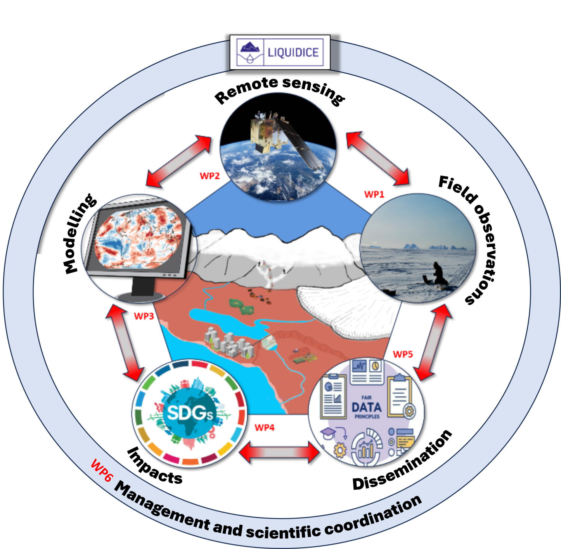
Multi-Scale Observations: From Ground to Space
LIQUIDICE employs a dual approach, combining field-based observations with satellite remote sensing. Field campaigns provide high-resolution, site-specific data, while satellite observations allow for a broader spatial and temporal perspective. This synergy enhances our ability to monitor crucial parameters such as Snow Water Equivalent (SWE), glacier mass balance, and permafrost temperature across selected super study sites, including the Alps, Greenland, Svalbard, and the Himalayas.
Bridging Gaps in Data and Model Integration
By consolidating existing datasets and conducting targeted field surveys, LIQUIDICE aims to improve the accuracy and coverage of cryospheric measurements. Advanced machine learning techniques, combined with Earth Observation (EO) data, enable the reconstruction of historical snow and glacier conditions, providing essential long-term perspectives on climate change impacts. These refined datasets serve as critical inputs for enhanced modeling efforts.
Improving Climate and Glacier Models
Climate models often struggle to capture the complexity of ice sheet and glacier dynamics. LIQUIDICE refines and extends these models by integrating real-world observations and remote sensing data, enhancing their ability to predict future cryospheric changes. By improving downscaling techniques, we ensure that simulations provide realistic and high-resolution projections for local and regional assessments.
Understanding Societal Impacts
The cryosphere is not just a scientific curiosity—it directly influences water resources, energy production, and local communities. Through interdisciplinary research, LIQUIDICE examines how changes in snow cover and glacial melt affect hydropower production, drinking water availability, and winter tourism. Our collaboration with policymakers, environmental agencies, and local stakeholders ensures that our findings translate into actionable insights.
Towards a Sustainable Future
By combining state-of-the-art data collection, technological innovation, and interdisciplinary collaboration, LIQUIDICE is setting new benchmarks for cryospheric research. Our commitment to open-access data and engagement with global climate initiatives strengthens the project’s impact beyond academia, contributing to a more resilient and climate-aware society.